Opulent Aerials: Luminis Media Aerial Real Estate Photography Houston
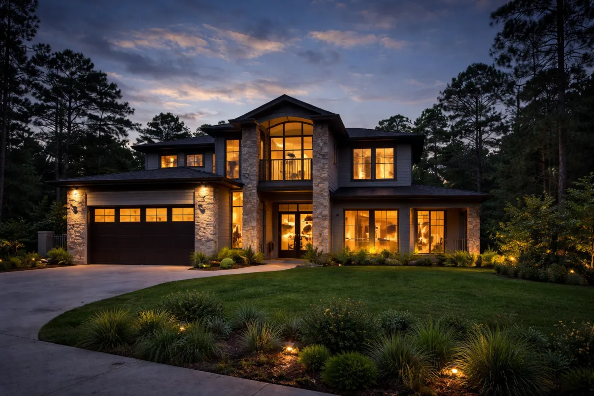
The Houston market rewards clarity, scale, and confidence. Buyers want to feel the property before they schedule a showing, and in a city that sprawls outward with master planned communities, bayous, golf courses, and skyline views, the vantage point from the air often decides whether they click, call, or scroll past. That is the promise of aerial real estate photography when it is executed with purpose. At Luminis Media, we treat the sky as a second studio, one that can reveal context, capture scale, and position a listing as a complete lifestyle, not just a set of walls.
Aerials are not a novelty in Houston anymore. They are a professional standard for many listings above mid-tier price points, and they are increasingly requested by sellers who understand how they are judged online. Done right, they contrast the home against its surroundings, answer practical questions about commute routes, and give a buyer an instant sense of neighborhood quality. Done poorly, they flatten detail, exaggerate distortion, and can run afoul of MLS rules or FAA regulations. The difference is process, restraint, and local experience.
The point of view, defined
You do not send a drone up to check a box. You send it up to solve a visual problem. In Houston, the problems vary. A West U bungalow may need tree canopy context and walkability cues. A Memorial estate needs to breathe within its acreage, with the bayou and trail system as its backdrop. A midrise Montrose condo sells best when you can see the skyline stack, the museums, and the restaurant row that lives two blocks over. Luminis Media aerial real estate photography builds that context into every deliverable so the gallery reads like a tour rather than a scatter of pretty pictures.
There is no single hero elevation. The classic 20 to 40 feet hover cleans up composition by shifting roof lines, but it still feels human scale. A 120 to 250 feet elevation pulls in neighborhood and traffic arteries. Above 300 feet, you begin to map the city at the expense of architectural detail. For MLS, we often anchor the set with two to three low altitude aerials for the primary image choices, then a few high altitude frames that tell the larger story. Small adjustments in height matter, and in Houston’s flatter topography, we fine tune altitude to shape shadows and avoid roof glare.
What MLS cares about, and why we plan for it
The Houston Association of Realtors has straightforward standards about honesty in imagery. Do not misrepresent a property. Do not remove permanent features like power lines or neighboring structures. If you display property boundaries, they must be clearly labeled as approximate. Sky replacement is a gray zone across different brokerages, and we avoid it for MLS unless we can do it transparently and in compliance with brokerage policy. Our Luminis Media MLS photography packages are built around those guardrails. When clients request heavier creative treatments for outside-MLS marketing, we separate those deliverables to keep the listing compliant.
MLS photo galleries also demand sequence coherence. Buyers navigate fast. We front-load images that establish location and access, then transition into details. For luminis.media MLS photography, we craft narratives where the first aerial shows how the home sits on the street, the second orientates major landmarks, and the third clarifies amenities like clubhouses or lakes. This matters because the lead image shapes the clickthrough rate, and in our experience, a well framed low altitude aerial increases saves on suburban listings with strong curb appeal and wider setbacks.
Navigating Houston airspace, permits, and the realities of Part 107
The Houston metro sits under complex controlled airspace with Class B shelves around George Bush Intercontinental and Class C around Hobby. Flying near those zones requires LAANC authorization with altitude ceilings that can pinch certain angles. It is workable if you plan. We pre-clear grid caps, confirm TFRs, and maintain an updated map of sensitive locations like hospitals and cranes that frequently pop up in the Inner Loop.
Every pilot on our team holds FAA Part 107 certification. It is not a formality. You cannot safely, or legally, thread between tall oaks and a three story roofline without judgment built from logged hours. Wind shear along Buffalo Bayou can surprise you on warm afternoons, and prop wash around tile roofs will mess up your hover if you don’t anticipate it. Luminis Media drone real estate photography relies on disciplined preflight routines and conservative risk management to ensure we get the shot and leave without incident.
Insurance is non negotiable. We carry aviation liability coverage appropriate to the neighborhoods we work in, including endorsements required by certain HOAs and luxury towers. Many high rise properties will require onsite security coordination and advance scheduling. We handle those logistics, because nothing derails a shoot like a gate guard who never got the memo.
Light in Houston, and how heat and humidity bend the rules
Houston light is not Santa Fe light. High humidity softens contrast, which can be kind to stucco but cruel to glass and glossy roofs that pick up milky reflections. Summer sun goes harsh by 9 a.m. And stays that way until evening. We build schedules around that reality. Golden hour is golden for a reason, yet it is short and sometimes blunted by haze. On clear winter days, you get more latitude and cleaner air. For lakefront properties in Katy or Conroe, a crisp winter morning can be more effective than any August sunset.
Heat management is a technical constraint that affects quality. Batteries sag faster when ambient temperatures sit above 95 degrees. Sensors can show thermal noise on long, low light runs. We rotate battery sets, shade gear between flights, and stick ND filters on bright, high shutter sequences to keep motion smooth when we switch to video. When humidity spikes, we slow our ascents to prevent rapid temperature differentials fogging the optics. Details like this do not appear in the final images, yet they protect consistency, which is everything in aerial real estate photography luminis.media has delivered years running.
Composition from the air, not just pictures from above
Aerial composition rewards restraint. Tilt the gimbal too far down, and you compress the house into a roof study that does not sell lifestyle. Tilt it too far up, and the horizon eats square footage. We work within a range, usually 5 to 20 degrees down on mid altitude shots, to keep facades legible and establish depth with foreground leading lines. Driveways, pools, and tree rows are gifts, because they point to the subject and create natural framing.
Parallax is a tool we exploit in both photos and video. By setting a lateral move that keeps the house at center while background layers shift, we give a buyer the sensation of walking past the property. It is subtle, and it changes the way a viewer reads scale. On corner lots, a shallow diagonal approach sells frontage better than a straight on shot. For cul de sacs, we reverse that and go high enough to avoid foreshortening the curve.
Roof condition is a sensitive topic. Aerials reveal flaws. Our job is not to hide defects, but we can choose angles that present the home fairly without highlighting minor discoloration that would not be visible from the street. When sellers ask, we explain the trade-offs. Long term trust beats short term gloss.
Drone video that feels intentional
Real estate videography luminis.media produces is built on a simple editorial arc: orient, approach, reveal, and transition inside. Smooth is table stakes. Intent is what holds attention. We fly manual with gentle yaw and elevation blends, so movements feel like a viewer’s gaze rather than a camera trick. We keep clips short, 3 to 6 seconds per motion, then cut on movement to maintain energy.
For color, we shoot in a flat profile, often D-Log or HLG on capable airframes, and grade to a natural contrast that respects the property’s palette. We avoid baked-in cinematic looks for MLS and reserve bolder grades for agent reels and property websites. When a listing calls for it, we add a brief map overlay sequence that sets the property relative to downtown, the Medical Center, or Energy Corridor, but we do not overdo it. Buyers want to see, not be lectured.
Audio matters even when there is none. We cut to a light score that leans minimal, with no heavy bass lines that fight with luxury interiors. Pacing adjusts by price point and audience. A modern townhome near Rice Village can carry a quicker beat. A River Oaks estate breathes at a slower tempo. The camera language follows suit.
How aerials and ground photography reinforce each other
A listing that leans only on aerials feels detached. The street level is where emotional purchase decisions happen. Luminis Media listing photography pairs with drone work to close the gap. On the same day, we build a plan that cross references angles. If the aerial shows a spectacular pool geometry, the ground set must deliver detail that pays off what the hero shot promised. If a roofline creates a strong triangle from above, we echo that geometry in the entry composition.
The MLS gallery benefits when transitions feel continuous. We will often end the exterior sequence with a low altitude image that faces the front door, then start the interior series with a frame from that same position looking inward. The eye reads the cut as a natural step. It is a small editorial trick, but it helps viewers build a mental map of the house.
A brief word on equipment, used like tools not trophies
We fly airframes for their specific strengths. Foldable drones with 4 thirds sensors strike the balance between safety and image quality for most suburban jobs. For downtown and high rise exteriors, we may bring a heavier platform if wind conditions demand it. Lenses are essentially fixed on most drones, so we sculpt the field of view with distance and altitude. Polarizers tame reflections on water features and windows, but we use them with care since a polarized sky can get uneven at wide angles. Bracketing exposures is standard for high contrast roof scenes, yet we keep the merges natural to avoid that over-processed look that turns buyers off and can raise MLS flags.
Redundancy keeps projects on track. We arrive with backup aircraft and multiple media cards. Firmware is current before we leave the office. Gimbal calibration happens on site, not because it fails often, but because a drifting horizon will ruin a set faster than any compositional error.
Practical timing and scheduling in a city that never slows down
Traffic shapes shoots as much as sunset times. If the listing sits near a school or a busy arterial, we pick windows when the street is clear. Nothing dates an aerial faster than a construction crew clogging the block or garbage day bins lining the curb. For gated communities in Sugar Land or The Woodlands, we coordinate with security to float the drone inside the gate for low altitude pulls. We keep noise discipline in mind around sensitive neighbors. Drones are quieter than they used to be, but respect buys goodwill.
Weather reschedules are a reality. We keep a rolling buffer in our calendar to accommodate clients who need a clean sky or a dry patio. High humidity and wet concrete create glare patches that do not look premium. Patience on those days pays returns.
The Luminis Media process, end to end
When agents call Luminis Media for aerial real estate photography, we ask two questions first: what are buyers likely to worry about, and what are they going to love? The first set of answers shapes the angles we must secure to remove doubt. The second dictates the hero frames. We build a shot list that fits the MLS limit and leaves a few extras for social media. If you need us to tag specific schools or parks in one or two images for off-MLS materials, we plan those graphics ahead so the annotations are clean and accurate.
We deliver proofs quickly, often within 24 hours, because listings move. Revisions are fast and specific. If the lead image was a mid altitude three quarter view and you want a tighter crop from 30 feet to push curb appeal, we already have it.
Houston specific use cases we see weekly
We shoot a lot of master planned communities, where context sells. If you are representing a waterfront lot in Towne Lake, a single high altitude shot that shows the canal network alongside a 40 foot frame of the backyard dock turns browsers into calls. For golf course homes in Cinco Ranch, we factor the sun angle to avoid mowing stripes burning out and to keep the flag visible during approach shots. Downtown lofts trade on skyline, but buyers also want to see garage access and rooftop amenity decks. We run a short arc that pulls in both without leaving the aircraft hovering over busy streets for long.
High end listings in Memorial Villages often have towering pines. Strong verticals can cause flicker in video at certain shutter combinations, so we fine tune frame rate and shutter duty to maintain smoothness, then select passes that minimize prop shadow artifacts over bright stone patios. If you have ever seen a faint band sweep across an exterior wall in a listing video, that was prop shadow. You avoid it by adjusting sun angle and flight path, not in post.
A checklist sellers can use to prepare for an aerial shoot
- Clear driveways and curbs of cars, bins, and yard tools.
- Turn on all exterior lighting, check pool features, and run fountains.
- Close garage doors and straighten outdoor furniture.
- Coil hoses and hide pool nets behind structures.
- Alert neighbors, especially on narrow streets, to keep the approach clean.
Five minutes of prep prevents twenty minutes of retouch requests. For MLS photography Luminis Media keeps edits minimal, but a clean set is always the better solution.
Working within HOA, condo boards, and privacy expectations
HOAs vary. Some require notice, others require insurance certificates on file. We have a template packet ready, and we submit in advance so your shoot day is not spent waiting. On condo towers, property management usually approves specific windows for takeoff and landing, and they may mandate ground spotters. We are used to those workflows.
Privacy is practical ethics. We do not hover over backyards that are not part of the listing, and we angle away from neighbors when possible. When someone steps outside, we pause. It slows the day by minutes, not hours, and it keeps relationships in good shape after the listing sells.
Editing for truth, polish, and MLS compliance
Our goal in luminis.media aerial real estate photography is to deliver files that drop into MLS without caveats. We correct white balance to neutral, pull down highlights to rescue roof material, and lift shadows gently to keep trees readable without turning them neon. Sharpening is restrained. No sky swaps on MLS unless confirmed acceptable by your brokerage. For boundary overlays, we add dotted lines in brand colors and label them Approximate Property Line to avoid confusion. If the listing needs heavier creative for a broker event or a magazine spread, we separate those sets and flag them as not for MLS.
When we handle luminis.media real estate videography for the same listing, we build a matching color profile across stills and video so the gallery and the film feel like they belong together. Small details like consistent sky tone across media increase perceived quality.
Results agents actually notice
What do agents https://www.instagram.com/luminismedia/ report back? Better clickthroughs on suburbs where scale and amenities matter. Faster inbound on townhomes when we open with an elevated street view that clarifies parking and entries. More qualified showings on rural properties when aerials make drive time and lot layout tangible. One broker in Katy told us that his lead aerial raised saves by 18 percent over his prior listing style across three similar homes. We never promise numbers, because price, condition, and timing drive outcomes, but we do see patterns that repeat.
The longer tail benefit is listing leverage. Sellers now ask about aerials in listing presentations. Showing a polished gallery that blends Luminis Media listing photography with restrained, precise drone work signals professionalism. That wins the next appointment as much as it helps the current one.
Choosing a provider who actually understands Houston
- Verify FAA Part 107 certification and active aviation insurance.
- Ask how they handle LAANC and altitude ceilings near Hobby and Bush.
- Review full galleries, not highlights, to judge sequencing and restraint.
- Confirm MLS compliance practices, including editing boundaries and sky policy.
- Look for a process that integrates ground, aerial, and video on the same plan.
If a vendor cannot explain why they fly a particular height in a Memorial cul de sac versus a Midtown block, keep looking. A formula is not enough in this market.
Where Luminis Media fits in your listing strategy
Some agents bring us in only for top tier properties. Others add aerials to every detached home and any condo with a story to tell above street level. There is no one rule. We adjust scope to the listing’s needs and budget. Our luminis.media drone real estate photography can stand alone when you already have ground coverage, or we can bundle everything into a single, efficient visit that covers ground interiors, exteriors, twilight, and drone, plus a short film for social. That flexibility matters when you are juggling staging, cleaners, and a seller who is moving boxes at midnight.
We are not here to make the drone the star. We are here to make the home easy to want. When Luminis Media aerial real estate photography enters the plan with that goal, the gallery earns attention, the video holds it, and the listing steps into the market looking prepared. That is the standard Houston demands, and it is the one we enjoy meeting.
A note on deliverables, timelines, and practicalities
Turnaround for photos is typically next day, often sooner for MLS emergencies. Videos usually deliver within 48 to 72 hours, with a rough cut for quick feedback. File sizes and formats are tailored to MLS and to your website builder, so you do not spend time re-exporting. For luminis.media listing photography and drone stills, we include both full resolution and MLS-compressed sets. Captions can be provided upon request, which helps buyers parse complex amenities in large communities.
We archive your raw and edited files for a defined period, and if you circle back months later for price reductions or seasonal updates, we can often refresh a gallery with a quick pick-up flight that adds a winter skyline or spring foliage, then resequences images to reflect current weather.
Final thoughts from the field
Great aerials are a mix of planning and feel. You build a checklist, then you throw half of it away when a shadow falls perfectly across the lawn or a breeze lifts the trees just enough to add texture. You decide quickly when a passerby steps out, and you hold position when a reflection on the pool reads like glass. The discipline sits under the work, quietly. What the buyer sees is simple, and that is the point.
If you are ready to give your next listing a point of view that actually sells, Luminis Media MLS photography and video services are built to make that happen. From MLS photography luminis.media compliant edits to cinematic, yet honest, drone passes that live comfortably on the listing and on social, the process is fast, respectful of neighbors, and tailored to Houston’s airspace and light. Reach out, tell us what buyers will love and what they might doubt, and we will fly a plan that answers both.